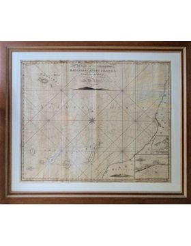
NORIE, J. W. THE NEW AND CORRECT CHART OF MADEIRA & CANARY ISLANDS, with the adjacent Coast of Africa drawn from the latest Surveys by J. W. Norie, Hidrographer, &c. [Londres]. 1814.
Em moldura de caixilhos recentes com dimensão exterior de 84x99 cm.
Mapa náutico de 64x79 cm. Compreende o Oceano Atlântico e a costa ocidental de África entre os graus 27º 8’ ao 33º 7’ de latitude Norte e entre os graus 8º 9’ e 18º 5’ de longitude Oeste.
Legenda na margem da mancha gráfica: « Drawn by J. Norie, Teacher and Navigation, nº 157 Leadenhall Street. // London, Published Aug. 21ft, 1814 as the Act directs, by J. W. Norie and Cº (late Heathers) Navigation Warehouse, nº nº 157 Leadenhall Street. »
Contém 2 perfis de ilhas e um plano da baía e da cidade do Funchal (de 14x17 cm) inseridos na carta e com as legendas:
Appearance of the Island of La Palma.
View of the Madeira Island.
The bay of Funchal from recent survey.
BNP não refere.

 Português
 Inglês