[In] ISOLARIO DEL P. CORONELLI. Veneza. S/d [circa 1690].
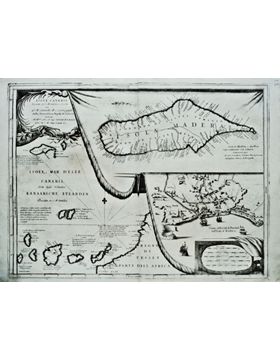
1 fólio maior desdobrável de 46x60 cm. com mancha gráficas do mapa atlântico colocada em 'janelas sobrepostas' representando (sobre o Oceano Atlântico em pano de fundo) os mapas de pormenor da Madeira e do Funchal, cartografados sobre as dobras de uma pele ou pergaminho.
Desta forma representam-se no mesmo fólio 3 mapas: A) Oceano Atlântico desde a Latitude das Ilhas da Madeira e do Porto Santo (representadas em geral); as Canárias; e a Costa Ocidental da África; até ao Cabo Bojador. B)
A Ilha da Madeira (mapa aumentado e em pormenor) com todas as suas localidades e povoações costeiras; a sua orografia interior; e uma linha tracejada da sua divisão política em 2 capitanias gerais: Funchal e Machico. C) Vista de pormenor da planta da cidade do Funchal em perspectiva cartográfica. Título e notas do impressor: 'ISOLE CANARIE Possedutte da S. M. Cattolica, e descritte dal P. M. Coronelli M. C. Cosmografo della Seenissima Repub: di Venetia dedicata All' Illmo. et Eccell. Sigr. ALVISE DA MOSTO Procr. di S. M. Sauio Grande, et c. / ISOLE, E MAR DELLE CANARIE Dette dagli Hollandesi KANAARICHE EYLANDEN Possedute de S. M. Cattolica. / REGNO DI TESSET PARTE DELL AFRICA. / isola di MADERA, ó du Bois la piu settentrionale delle Canarie scoperta nel 1420. / Veduta della Città di Fanchal nell'Isola di Madera'.
[EN] Venice.[Circa 1690]. 1 large folio (46x60 cm). Atlantic map in patches 'overlapping windows' representing: the Atlantic Ocean in the background, and detailed maps of Madeira and Funchal City; observed as designed in the folds a parchment. Therefore it represents in the same folio 3 maps: A) Atlantic Ocean, from the latitude of the islands of Madeira and Porto Santo (general view); the Canary Islands; and the West Coast of Africa to the latitude of Cape Bojador. B) The Island of Madeira (enlarged and detailed map) with all its coastal towns and villages, their inner creeks, and a dashed line its political division into 2 general captaincies: Funchal and Machico. C) View of detail in the plan of Funchal in cartographic perspective. Title and printer's notes 'ISOLE CANARIE Possedutte da S. M. Cattolica, e descritte dal P. M. Coronelli M. C. Cosmografo della Seenissima Repub: di Venetia dedicata All' Illmo. et Eccell. Sigr. ALVISE DA MOSTO Procr. di S. M. Sauio Grande, et c'. / ISOLE, E MAR DELLE CANARIE Dette dagli Hollandesi KANAARICHE EYLANDEN Possedute de S. M. Cattolica. / REGNO DI TESSET PARTE DELL AFRICA. / isola di MADERA, ó du Bois la piu settentrionale delle Canarie scoperta nel 1420. / Veduta della Città di Fanchal nell'Isola di Madera'. Corresponding to a detached folium from the Atlas (circa 1690) 'ISOLARIO DEL P. CORONELLI'; containing 2 printed pages in the reverse folium 93-96.

 Português
 Inglês